TO THE ENDS OF THE EARTH
AT SOME epoch in the remote history of pre-Dynastic Egypt, the abundant rains began to decline and a creeping aridity enveloped the region. The task of husbanding the land became ever more difficult, as year upon year the fields yielded lesser quantities of grain at harvest time. By about 4,000 BC the inhabitants of Egypt and its satellite countries, where Adamic/ Indo-European peoples had dwelt for Millenniums, began to look for more verdant homelands, primarily in Western Europe.
Way mark trails, composed of cairn, standing stones and dolmens were erected all the way across the top of North Africa, from Israel to the Straits of Gibraltar. The way mark trails continued up the coast of Spain, Portugal and France to Scandinavia. It is the view of many scholars that the general usage and scientific applications of standing stones or other types of stone landmark monuments, achieved their greatest sophistication in the British Isles, a region known to the ancients as the ‘Isles of the West’. What remains of the ancient trails today points the way back to the place from whence peoples of the modern European nations came (See Palestine, by Major C.R. Conder, R.E., George Philip & Son, 1889, pp. 142-157).
Further evidence of this mass migration out of the Near & Far East is found in Pre-Dynastic Egyptian skull types or those of Mesopotamia from 5,000 years ago. These can be matched to types found in 17th Century, London plague pits or Neolithic cist graves in Switzerland (See Races of Europe, by Professor C.S. Coon, Macmillan, N.Y., 1939).
The new settlers of Europe brought the totality of their age-old knowledge with them, including measurement standards and astronomical methods. They would need these in order to set out precisely fashioned standing stone circles, by which they could continuously gauge the Earth’s relative position against the backdrop of stars.
Rise and set equinox and solstice positions were located on the distant horizon and marked by standing stone or sighting trench alignments, which orientated onto these significant solar points. The age-old Sabbatical Calendar system, as encrypted into the Menkaure Pyramid’s base measurements, was reinstated for the fluid maintenance of organised society. The former residents of Egypt had carried all of the tenets of civilisation to their new homelands in Europe or the distant colonial outposts scattered around the world.
One region where there was a religious, uncompromising adherence to maintaining the integrity of the original measurement standards was Great Britain and we are now able to prove mathematically that the pyramids of the Giza Plateau were built exclusively to the same rneasurernent standard as found in ancient British structures (e.g. Stonehenge). Therefore, In British measurements we see a survival of this most ancient measurement standard, used by Indo- European peoples since time immemorial.
Thankfully, by close comparative analysis of remnant structures like the Great Pyramid or Stonehenge’s Sarsen Circle, we can understand anew the exact lengths of lost measures like the league or reed. We now know, also, that the so-called Dynastic Royal Cubit was an appendage to the British Standard of measurement and was not essentially a ruler at all, but a mnemonic device used for remembering the size of the Earth.
Three geodetic systems, for worldwide navigational purposes, have been identified in the extractible lengths, angles and general geometry of the 3 main pyramids of the Giza Plateau. These are also found at Stonehenge.
The ancient inhabitants of Egypt and Britain were adept navigators and had sophisticated grid and angle calculating mathematical systems, which allowed them to move around the globe with total freedom.
One of the navigational systems found upon the Great Pyramid used leagues of 16500 feet, miles of 5280 feet, furlongs of 660 feet, chains of 66 feet, rods/ perches of 16.5 feet, fathoms of 5.5 feet and links of 7.92 inches.
For further, in depth reference on how the Great Pyramid codes these lengths see the website: http://www.celticnz.co.nz
New, emerging archaeological evidence shows that there was tremendous diffusion of culture and trade from the Mediterranean Basin and the Atlantic coastal countries of Europe to the Greater world in ancient times. Evidences of this can later be seen in the worldwide maritime exploration of the Phoenicians (Hebrew Danites), the ships of Tarshish, as well as the fleets of Egypt and King Solomon of Israel. This maritime tradition continued unabated amongst progenitors (ancient Britons/ Celts) who were directly related to the earlier explorers from the Eastern Mediterranean.
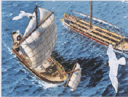
Many obsolete concepts of Classicist historical interpretation need, finally, to be laid to rest, such as those suggesting that ancient Britons had no developed shipwright skills and were limited to the use of coast hugging, leather coracle boats. This was not the experience of Julius Caesar when he began the invasion of Gaul in 55 BC and was confronted by 220 large, Celtic Swan ships. Had the wind not died away to nothing on the day, there might never have been any Roman incursion into France and Britain. Caesar, who wrote about the combined Gallo-Britannic fleet, described the ships as deep-water vessels capable of open sea traversals (‘Vasto atque aperto mari’, ‘upon the vast open sea’… (ref ‘De Bello Gallico, Book Ill, XIII, I‘). This lends credence to the fact that ancient shipping was highly developed and that mariners could and were plying trade routes to far distant locations.
Picture by Hervey Garret Smith, taken from
Men, Ships and the Sea, by Capt. Alan Villiers.
A drove of authors, like M. Scott Peck in his book, In Search of Stones, put forth views that the standing stone circles of Great Britain are unique to that solitary region and are found nowhere else on the planet. This is quite wrong, as similar structures are found from Egypt to Nova Scotia and greater North America. We are now finding them in the remote Islands of New Zealand, at the very ends of the Earth (The lands of Sinim? … Isaiah 49:12).
The style and functions of our New Zealand astronomically based or overland, trig-mapping structures, exhibit a direct pedigree to Great Britain’s Megalithic and Bronze Ages. We also find that our ancient standing stone circles are set out, undeniably, to British Standard measurements.
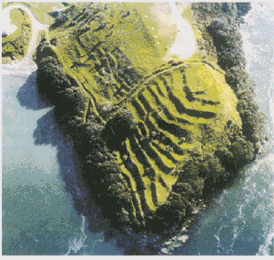
 Picture from, Historic Places in New Zealand Magazine, June 1983.
This is said to be a Maori Pa (hill and peninsula fortifications) and within New Zealand there are upwards of 1500-registered Pa sites. The styles of construction are exactly the same as Bronze Age to Iron Age British hill forts. The New Zealand varieties tend to replicate the earliest British styles, where pallisaded barrier fences were erected to keep an enemy at bay. British Archaeologist, Allene Fox, amongst others, commented on the startling similarity between hillfort styles at opposite ends of the globe. The massive undertaking to build so many large fortified positions cannot, realistically, be attributed to the Polynesian Maori, whose advent into New Zealand was in the 13th or 14th centuries AD. Population models, related to Maori, simply do not work and cannot account for so many varied, structures or difficult engineering feats, within the span of so few centuries. Other typical British styles occur in large channel and drainage systems, stacked stone walls, stone lined embankments, inter-locking stone Beehive hovel domes, mounds & tor mound hill markers, cairn and standing stone surveying trigs, jade carvings, double spiral or chevron art styles and astronomical systems.
Maori oral tradition speaks of a people who were once numerous (‘as ants upon the land’), occupying New Zealand when Maori first arrived. They were described as people of light complexion (kiri puwhero), with hair that was reddish or golden tinged (uru kehu). These people were ‘pacifists’ and were later annihilated by the warrior/cannibals. Remnants of the earlier group were seen by early maritime explorers and sizable pockets of ‘red headed’ Maoris existed into the 20th century.
Trussed, sitting or foetal position burials, like those of Britain’s Beaker people, were very common in ancient New Zealand and, where encountered, oftimes indicate the pre-Polynesian inhabitants. Many such skeletons or others found in remote burial caves, show no Polynesian attributes, such as the ‘rocker jaw’ with its continuous downward curve on the lower border. Unfortunately, official New Zealand archaeological endeavour is locked into serving the dictates of political correctness and racial sensitivity, to the extent that no carbon dating or DNA analysis is permitted on these types of rernains.
In an age of rapid scientific advancements, New Zealand archaeology is not allowed to move forward in an atmosphere of normal scholastic pursuit. Our ‘social’ engineers, historians, archaeologists and government departments doctor the facts and are guilty of deliberate sins of omission, as well as sins of commission, designed to curtail the emergence of new perspectives.
Some semblance of the true historical picture is beginning to emerge via the efforts of amateur researchers and it is becoming increasingly clear that many cultural expressions, attributed to a Maori origin, are not Maori at all. The oldest ornately carved Meeting Houses are close in concept to early British styles of construction, with the intricately patterned carvings closely paralleling traditional forrns of Celtic art.
We are also finding compelling evidence of inbuilt mathematical coding in the oldest Meeting Houses, based upon the British Standard foot and exhibiting the most profound astronomical numbers used in ancient Britain and the Mediterranean Basin. These buildings were, clearly, not of Maori origin (unless Maori also built Stonehenge and the pyramids), but came into their possession as the fruits of conquest. A good example is the Crosshouse of Miringa te Kakara, destroyed by fire in 1983.
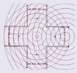
The Crosshouse ground plan, drawn by architect PG. Hunt, in 1958, prior to planned restoration of the historic building. It is here shown demonstrating some of its PI (3.1416) coding, with exact PI increments set to British Standard feet. Each circle expands by 7.854 feet diameter (1/4th PI set to precise foot & inches measure). The 2nd PI expansion from the centre post relates to where the central walkway turns to the diagonal. The 3rd expansion complies with the edges of special ‘wrap around’ corner mouldings. The 4 th PI expansion is exactly 31.416 feet and brushes the outward faces of the secondary posts. The 6th expansion runs to the internal corners of each wing and overshoots the door line by 3 inches. This is because the door threshold was coded to a PHI value (1.6180339) & not a PI value. The distance between thresholds was 46.6 feet, which is a very important Stonehenge value @ 466 feet. That value, marked on the Avenue at Stonehenge, was found by a PHI increase on the diameter of the Aubrey Circle (288 feet X PHI = 466). The primary codes of Stonehenge, including that of ‘Y’ Holes are found within the Crosshouse (ref Articles 3-4 @ http://www.celticnz.co.nz)
Members of the Maori Hau Hau religious movement first restored the Crosshouse of Miringa te Kakara in the 1860’s, in order to entice back the ancient ‘Fairy People’ called, by the Maori, Patu-pai-arehe. In the process of restoration and ongoing maintenance, a tradition was adhered to that no part of the building could be modified and each deteriorating part removed had to act as the template for a new replacement part. The Maori renovators obviously knew the building contained special information and codes, although there is nothing outwardly apparent in their culture to suggest that they were conversant with the special encrypted knowledge.
Whereas New Zealand based academics would have us believe that the Crosshouse was conceived and built in the 19th century, some Maori oral traditions refer to a much earlier, pre-colonial pedigree. The building is extremely complex mathematically, with copious usage of the PHI ratio and Northern European or Egyptian astronomical codes. Even adept colonial European architects of the mid-1800s would have been unable to design and correctly fabricate this building. There was, simply, no way that they could know and understand the multiples of special astronomical or geodetic, ‘ring of the Earth’ codes, still awaiting rediscovery.
The voice of the ancient people is long silenced, but they continue to speak to us eloquently out of the dust, through their remnant standing stone circles, artefacts or deteriorating structures.


