WHERE IN NORTH AMERICA DID THE VIKINGS SETTLE?
Despite what the establishment historians would like you to believe, L’Anse aux Meadows is not the Vinland described in old Norse sagas. Vinland is the entire island of Newfoundland, as shown herein by evidence from three separate disciplines: navigation, geography and history – all corroborating. Driving from St John’s to St Anthony one can view the sites seen by Leif Eriksson and Thorfinn Karlsefni en route.
MANY people have been persuaded that a small archeological site near L’Anse aux Meadows (hereinafter simply L’Anse aux Meadows), at the northern tip of Newfoundland Island, is the Vinland of the Norse sagas. In 1964, National Geographic published an article by Helge Ingstad which stated,
“Perhaps Leif Eriksson himself had beached his ship and lived on this grassy bay shore.”
Ingstad goes on to say that the site contained the remains of the foundations of nine ancient structures, the heart of a Norse community that stood here “soon after A.D.1000” That is the approximate time of Leif Eriksson’s voyage to the land he named Vinland. However, the physical attributes of Vinland, described in the sagas, are not the same as the attributes of L’Anse aux Meadows.
Instead of being on a westerly course around the headland, L’Anse aux Meadows is directly on the headland. Instead of a river on which they brought their ship to a lake, there is a rock-strewn creek, neither wide enough nor deep enough to float a ship that carried a crew of 35. It will not accommodate a canoe. According to the sagas Leif’s crew had anchored in the lake and on its shore had built homes – not on the shores of a bay, as at L’Anse aux Meadows.
There is a site which fits all the characteristics of the earliest settlement as described in the sagas. It will be located within this presentation. In addition, a second spot described in the sagas, the place where Thorfinn Karlsefni and his wife Gudrid attempted to found a colony, will also be located.
Vinland is Newfoundland. It is not some little island; it is not all of America (Leif Eriksson had already named two other parts: Markland and Helluland). Nor is it New England.
There is evidence in each of three disciplines that the Vinland of the Norse sagas is today’s island of Newfoundland. The three disciplines are navigation, geography and history
UNLIKE many other voyagesof discovery in which we are dependent on a single voyage and a single report (Christopher Columbus’ first voyage, for example) we have in the Vinland sagas five separate voyages and five reports. As regards navigation there are 11 specific items, each corroborating the other. The basics of navigation are distance and direction. The Vinland sagas provide both.
Aboard a Viking ship at night, the navigator takes a sighting on the North Star to detennine the ship’s bearings. The Vikings were certainly more daring as seamen than others of their era. The magnetic compass was not invented until the 12th century. Recent research has revealed that what had appeared to be random scratches on the Greenland “bearing dial” actually mark the shadow of the sun at that latitude, enabling a navigator to find the directions at times other than high noon.
Bjarni Herjolfsson had been the first to discover America. He did so after having been storm-tossed in a voyage from Iceland to Greenland. While he did so only in the sense of sighting America, the saga retained his information as to distances and directions. It was his report that inspired Leif Eriksson to explore further. Leif went ashore and named each of the three lands he encountered and which had earlier been sighted by Bjarni. Thus he was also given credit for discovering these lands. As will be seen, Leif’s navigational and geographical information, where retained in the saga, is in accord with Bjarni’s on each of the legs of the voyage.
The saga states Bjarni had “sailed before a southwest wind” – thus, he was headed northeast. The square-rigged ships of those days could only sail before the wind.
Leif reversing Bjarni’s course, headed southwest. Bjarni had arrived in Greenland at the Eastern Settlement of the Norsemen, the same area from which Leif departed. Now, as will be seen by the description which follows, Leif arrived in the same area of America from which Bjarni had departed. As the saga states it: The first landfall they made was the country that Bjarni had sighted last.
Bjarni had crossed over what we now know as the Davis Strait in three and a half days. Literally, the saga says four days, but the Norse used the word “day” for two meanings: one is a 24-hour day, and the other is the sunup-to-sunset day. Here the saga made clear that they made land as dusk was falling.The distance here between the lands is some 525 miles, making his average sailing speed 150 miles per day.
Both the great geographer Ptolemy and Marinus of Tyre had stated that average ship speeds in their time were in the range of 100 miles per day. In checking Norse speeds in the North Atlantic, this author found four old records of time elapsed while travelling between two points; dividing these by the distances involved gave speeds ranging from 73 miles per day up to 151 miles per day. We know Bjarni had been at the high end, as the saga tells us:
“But it now began to blow a gale, and Bjarni ordered his men to shorten sail and not go harder than the ship and rigging could stand.”
(The direction and distance are those between Labrador, north of Groswater Bay and the Norse Eastern Settlement in Greenland.)
ON the next leg Leif was headed south, but Bjarni had been headed north. Thus Leif’s account is: “They returned to their ship and put to sea and sighted a second land.” After landing there, “They hurried back to their ship and sailed away to sea in a northeast wind for two days until’they sighted land again.”
Bjarni’s account was: “They sailed before a southwest wind for three days before they sighted a third land.” As can be seen on a map, Leif’s account of two days begins after Groswater Bay, whereas Bjarni’s three-day account is inclusive of the distance across the bay and winds up with: “Then the wind failed.” Groswater Bay, separating northern and southern Labrador, is 18 nautical miles (n.m.) wide at its mouth -so large that one can sail out of sight of land in crossing it. It is “another land,” being separated along the coast, and it is “another land” in its differing physical appearance, as will be subsequently shown.
Leif reports: “They sailed to sea in a northeast wind for two days until they sighted land again. They sailed toward it and came to an island which lay to the north of it.”
Going down Labrador southeast and then south; that wind would have been a side wind. A side wind can propel a square rigger, but at a slower speed. This leg for Leif was some 170 nautical miles. In the two days stated, he averaged 85 miles per day. As they found dew on the grass, this would indicate they arrived here in the morning-thus two full days. Likewise, Bjarni’s “southwest wind” in going north had been a cross wind for him.
IN Leif’s account, after going ashore at the island, “They went back to their ship and sailed into the sound that lay between the island and the headland jutting out to the north.” A headland jutting out to the north and an island lying to the north of it is an apt description of the northern end of the island of Newfoundland. Next, “They steered a westerly course round the headland. There were extensive shallows [here].” Such is the case when one sails into the sound (the Strait of Belle Isle), then steers a westerly course around the headland, reaching the extensive shallows of Pistolet Bay.
We have checked the navigational details from Greenland down to Vinland. Now let us check the geographical data. From the five voyages described briefly in the sagas, there are 14 specific descriptions. Again there are no conflicts. Surely, in describing these physical features in the same manner, they were seeing the same things. Bjarni had described northern Labrador as “high and mountainous and topped by a glacier … worthless.” Leif said of it: “There was no grass to be seen, and the hinterland was covered with glaciers, and between the glaciers and shore the land was like one great slab of rock … I shall give this country a name and call it Helluland.” (Meaning “great-slabs-of-rock land.”) This area of Labrador above Groswater Bay is mountainous and barren, and there are glaciers, as both men said.
Southern Labrador, below Groswater Bay, is described by Bjarni thusly: “They could see that the country was not mountainous, but was well wooded with low hills.” Leif said: “This country was flat and wooded, with white sandy beaches wherever they went, and the land sloped gently down to the sea. This country shall be named … Markland.”(“Forest land.”)
PERHAPS you have read that the Norsemen found a river along this coast, flowing from east to west. If you were like me, this was immediately dismissed as impossible. But there is such a thing: a river flowing westward from the Atlantic Ocean inland. It is right here between Helluland (Northern Labrador) and Markland (Southern Labrador). This is Hamilton Inlet, and it connects Groswater Bay with Lake Melville. Geologically this is a rift valley forming an enormous tidal basin over 150 miles long. So, when the tide is going out, it flows eastward; when the tide is coming in, it flows westward.
As to the extensive white sandy beaches mentioned by Leif, no comment was included in Bjarni’s section, but one of the following expedition leaders, Thorfinn Karlsefni,did so. In fact it was his crew which named it: “They called this stretch of coast Furdustrands [wonder Strands], because it took so long to sail past it.”
After the Furdustrands, the saga records that the coastline “became indented with bays.” So it does, in southern Labrador. On a subsequent voyage, Thorvald Eriksson, another of Leif’s brothers, went into one of these bays: “Soon they found themselves at the mouth of two fjiords and sailed up to the promontory that jutted out between them.” This situation with two fjords entering one bay exists, where the Eagle River and the Paradise River converge into Sandwich Bay.
Next we come to the Strait of Belle Isle, which Bjarni’s account simply refers to as going from one land to another; Leif’s account describes it briefly, but again it is Karlsefni who gives it a name: “The expedition sailed on until they reached a fjord. They steered their ships into it. At its mouth lay an island around which there flowed very strong currents, and so they named it Straum Island… they named the fjord Straum Fjord.”
Strong currents are found in the Strait of Belle Isle, as the waters of the St. Lawrence Seaway flow out to sea. In the mouth of this strait is Belle Isle, which is a “bird island,” populated by wildfowl. Here the Norsemen gathered eggs.

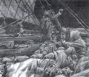
Norse men, women and children set up an initial encampment after achieving landfall in a strange country. Tents are set up for the leaders of the expedition while driftwood is gathered for fuel For the tirst few nights the lesser folk will have to sleep in the open or find what natural cover they can. Two knarrs, or merchant vessels, can be seen moored just offshore.
On the other side of the strait lies the northern promontory of Newfoundland. Leif named the land for the grapevine found here. As a consequence, those looking for Vinland have expected to find grapes there – but this ignores climatic changes, and nature now limits their range to latitudes farther south.
THERE was a third leg on Bjarni’s voyage, one which Leif did not pursue (other than the northern tip). Bjarni’s initial sighting had been some two days’ sail down the coast of Newfoundland. At the 100 mile-per-day average speed, this 200 miles would have placed him at the land north of Bonavista Bay. Here the land is just as Bjarni described it: “The country was not mountainous but was well wooded with low hills.” In this part of Newfoundland, the 100-footland elevation contour is a mile or two inland from the coast.
Later, Karlsefni would pursue this farther coast. But whereas Bjarni had sailed out to sea, anxious to find his father’s new home in Greenland, Karlsefni and Gudrid were travelling along a rugged coast seeking a desirable location for their new home. This type of voyaging requires daylight, and frequent use of oars rather than sails, in confined places. My findings from three sources indicated average speeds of 34 n.m./day under these conditions. This accounts for Karlsefni’s report: “They sailed south along the coast … for a long time and eventually came to the place [they chose to settle].”
Subsequent to Leif’s voyage to Vinland, his brother Thorvald made an expedition there. According to the saga: “There they laid up the ship and settled down for the winter, catching fish for their food.”
In the spring, Thorvald said they should get the ship ready and that in the meantime a small party of men should take the ship’s boat and sail west along the coast and explore that region during the summer. They found the country there very attractive.
“There were numerous islands there and extensive shallows …They found no traces of human habitation except on one westerly island, where they found a wooden stack cover … in the autumn they returned to Leif’s houses.”
In sailing west along the coast, it is not clear whether they proceeded clockwise or counter-clockwise around the Gulf of St. Lawrence. It could have been either inasmuch as they departed from the strait, but in either event they are bound to have come to the end of the island of Newfoundland and recognized as an island. The attractive area they found along with the numerous islands is descriptive of the Gulf of St. Lawrence, and so is the length of time for exploring it. Jacques Cartier’s exploratory voyage of the Gulf of St. Lawrence recorded a number of time frames between points, and these are in keeping with the overall time required for Thorvald’s exploration of the same area.
THE historical record is further evidence that Newfoundland is Vinland. The very earliest report still available to us is that of Adam of Bremen, a German monk who was at the court of the king of Denmark from whom he obtained the information that Vinland was an island and so published it about A.D.1075. The simple sentence, “Vinland is an island,” contains two clues: One is, of course, the word “island.” Secondly, the Norse used the morpheme “land” to mean a land mass of considerable size. Look at their other uses of that morpheme in this connection: Jutland (the peninsula and much of Denmark), England, Scotland, Shetland, Iceland and Greenland. As can be seen, each of these are sizeable and distinct bodies. None are villages. and neither are they continents. Leif Eriksson continued this manner of speaking in naming Helluland and Markland.
Vinland is both an island and a “land.” The only island west of Greenland which is large enough to be called a land is Newfoundland.
 |
|
When Leif Eriksson came toAmerica almost exactly I,000 years ago, most likely he sailed not on a romantic long ship with a dragon figurehead (above) but on a more prosaic-looking merchant vessel, or knarr; such as the replica shown here in the inset. The inset photo is of the Gothenburg (Sweden) Viking Ship Society’s knarr Vidfamne, modelled on the Askekarr ship, from around AD.930.
|
There is still one more area of evidence that the island of Newfoundland is the Vinland of the Norsemen. This is in the field of archaeology. The artifacts discovered are the Spirit Pond Runestones, which initially were pronounced fakes. At the time only nine words of the runic inscription had been translated. The reason for the difficulty was that the Norse in the period from circa 800 to about 1050 A.D.had shortened their alphabet (or “futhark”) down to 16 letters or runes. As a result, many runes had to symbolize two or more sounds. Coupled with this was the fact that the runic texts themselves had been virtually wiped out with the coming of Christianity into Scandinavia – they were associated with the pagan god Odin, who had been credited with teaching them to the Norsemen.
It was not until 20 years later that a complete coherent translation of the entire 97-word text was completed. It was then found that this contained internal evidence of authenticity.
One of the clues in the inscription is the description of the lake associated with Karlsefni’s “hop” as a bathing lake – that is, it was thermal. The inscriber used the word “lauga” (bath or bathing lake in Iceland), rather than “vatn” (the at the usual word for lake). This information was unknown in Newfoundland and everywhere else until the translation. It was published in a special edition of ESOP, the journal of the Epigraphic Society. Subsequently, reconsideration of the original determination has been recommended in the Massachusetts Archaeological Society’s newsletter, and in the newsletter of the Association of American Geographers.
A thermal lake area is described on the Spirit Pond Memorial Runestone. This is Gander Lake, and it can be examined by any traveller en route north from St John’s. It is the location of Thorfinn Karlsefni’s “hop.” Karlsefni was Leif’s brother-in-law, having married Gudrid, the widow of Leif’s brother. Karlsefni and Gudrid were attempting to set up a new Norse colony. Just as the bay, river and lake now all share the name “Gander,” so it was with Karlsefni using the name “hop.” He did the same with the settlement to the north, referring to it simply as “Straum Fjord,” which included the strait.
The Norse word “hop” is the name of the bay back in Iceland, next to the bay on which Karlsefni’s home was located. Some have thought that it means a tidal bay inasmuch as the bay in Iceland is now a tidal bay. This author thought so originally and that is still possible, but I now think it more likely that it was merely the bringing of a familiar name from back home as immigrants continued to do throughout the colonization of America.
In modern-day Newfoundland, Gander was not recognized as a thermal lake because it is relatively cold-but it is known to have a peculiar feature: It does not freeze over in the winter. Warm vapours off the lake in earlier times may account for Karlsefni’s statement: “They stayed there that winter. There was no snow at all, and all the livestock were able to fend for themselves.” The warmer climate would also have been a factor.
THE SPIRIT POND RUNESTONES……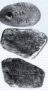
At L’Anse aux Meadows, in Newfoundland, a Viking presence has been officially acknowledged – But any suggestions of Viking presence south of this point in Norlh America are “verboten”. Nevertheless, Viking traces are found along the New England coast and even in interior North America. One of these traces consists of the “Spirit Pond Inscription Stones,” found in Maine by W Elliott in May 1971. They are covered with Norse runes. Since Spirit Pond is well south of the Viking “barrier,” the Inscription Stones have been declared a hoax. But this classification has not deterred out-of-the-mainstream archeologists from studying them. S. Carlson has endeavoured to translate the Inscription Stones. To her, they tell of Vikings trying to save their ship from “the foamy arms of Aegir; angry god of the sea.”
The Spirit Pond Memorial Stone describes four geographicfeatures of this site: (1) “Haakon [a common Norse name] found [a] fit strip of land,” (2) “to [the] west,” (3) “upon [a] bathing lake,” (4) “[which] gives [an] enormous region.”
IF you have an opportunity to travel in this area, as you drive down toward the lake, note: 1.The lake is to the west, off the sea. 2. The long shoreline and the ridge at the top form a “strip of land.” 3.And across the lake can be seen a wide, panoramic view of an “enormous region.”
The saga, in relating a visit by the natives, reported a fifth geographical feature: “They rowed away south around the headland.” If you will look south, you will see just such a headland.
That saga also tells of the initial finding of the site: “[They] eventually came to a river that flowed down into a lake and from the lake into the sea.” If you will drive a bit farther north on Highway 1 there will be a bridge which spans the Gander River, and here it flows from the lake down into the sea. You can rent a “Gander boat” (something of a cross between a canoe and a large rowboat, with a motor) and a guide to take you down the river. In its 24-mile run there is an 87-foot drop from the lake to the bay. There are four rapids, each of which is only a few feet deep with plenty of water coursing. It was a Sunday when the author went down – the local diversion on Sundays is to boat along the river.The rapids are so gentle that in one instance I saw a mother holding a small baby in her arms as they went across.We crossed three of the rapids,but our guide refused the fourth- explaining it was too shallow on the other side and could damage his motor.This fits the saga statement: “There were extensive sandbars outside the river’s mouth, and ships could only enter it at high tide.”
The deterrent against pirates which such an entry provides was one more plus for this site. It is the same type of protection which Leif had found on Pistolet Bay. (The sagas specifically stated pirates were a concern to Leif.)
As an alternative to boating down the river, you can drive down the road that runs parallel to Rte. 330. As you come to a left turn, on to Rte. 331, you will proceed on a causeway crossing Gander Bay.
Nowadays Gander itself is the location of an historic airfield – during World War II aircraft were ferried from here to England. Gander Lake also served, as it did not freeze during winter. Pan American landed their large Clippers (seaplanes) there when the bay was frozen over.
BEFORE going in search of a new home site, it appears Karlsefni followed the time-proven practice of going up on the highest point to have a look around before proceeding in uncharted waters. Elsewhere in the sagas this practice was mentioned. The highest point on the northern promontory isWhite Mountain at 1,075 feet.
That which is recorded on the map stone is the same as that which is visible within the 37-mile radius of the mountain – the line of sight to the horizon at that height. From White Mountain you can see the same geographical features which the inscriber showed on the Spirit Pond Mapstone: Belle Isle; Karlsefni’s Straum Island; Cape Bauld; the headland to the north; the Strait of Belle Isle; Straum Fjord; the coast of Labrador: Markland; Pistolet Bay; Hare Bay; the coast of Newfoundland and both Grey islands.
Further information on the Spirit Pond Mapstone is an arrow showing the Erection and a statement regarding the distance. The arrow, when the Strait of Belle Isle is aligned to true north, does give the correct direction to Iceland, and the statement of “12 days” is a remarkably good estimate of the distance. Actual distance is some 1,400 miles – a bit farther than 100 miles-per-day average would get there, but the prevailing winds are stronger here, and this is still well within the 150 mile-per-day range.
The reader may be thinking that a faker could easily have drawn this from a modern map. But this would not have been so easy as there is evidence of visual observation from the mountain top. Included are the errors of visual perspective – both the north and south coastal extremities are indented as they appear to the naked eye along the ridge of the hills here.
In addition there are two pieces of information which are not visible from this lookout point, but which were peculiar to Karlsefni.The firstis the landing place on the steep-sided Belle Isle.He knew about it because he had previously passed there. The second is information that was incorrect because he had not yet passed there – the inscriber showed the two Grey islands to the south were connected, which they appear from the mountain to be, but are not.
This information is in accord with the date shown on the Spirit Pond Memorial Stone, as well as a chronology of the Vinland voyages, calculated from the sagas: the year 1011.
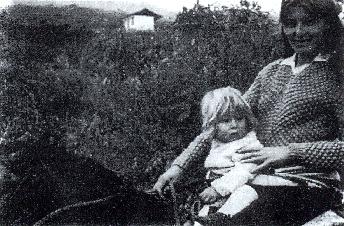 About the same time Leif Eriksson was settling in North America, other groups of Norsemen may have been landing in South America, says Prof Helmut Zettl of Vienna, Austria.
Were they the progenitors of the Incas, who emerged at about this time and became the rulers of a large empire in South America? In the village of Chirimoto in the Chachapoyas region of Peru’s Amazonas department, Zettl found apopulation half of which were blue-eyed and blond They speak Quechua, the Inca language, with a sprinkling of Norse words.
Here a Chirimoto woman and child are shown riding on a Norse-style pony.
AS you reach the northern end of Newfoundland, have a look across Pistolet Bay (from the road) and note how you can see the sandbars on which Leif’s ship was stranded when the tide went out. The nautical chart shows a passage around the western side of the headland, down to an anchorage. This is some three miles from the open sea – the same three miles as is shown on the charts of visibility range over the horizon for a man of 5’6″. The way the saga put it was: “There were extensive shallows there, and at low tide their ship was left high and dry, with the sea almost out of sight.”
Then the saga states: “But they were so impatient to land that they could not bear to wait for the rising tide to float the ship. They ran ashore to a place where a river flowed out of a lake.As soon as the tide had refloated the ship, they took a boat and rowed out to it and brought it up the rive rinto the lake, where they anchored it. They carried their skin sleeping bags ashore and put up booths [temporary shelters] . . . [later] houses.”
You will find a river, leading to a lake on the east side of the bay at Carpon Cove. Judging by his crew size of 35 men requiring 16 benches, Leif’s ship was approximately the same size as the Gokstad ship which has been restored and is now in the Viking Museum at Oslo, Norway. The Gokstad ship has a draft of 33 inches, and this requires a river of at least this much depth in order for the Norsemen to have brought it up river, as well as floating it down river with it’s load of timber. Note the presence of a river here and the lack of one at L’Anse aux Meadows. The brook there is so shallow you can walk across it on stones without getting your feet wet.
The Pistolet Bay location beyond the sand barrier offered a concealed place and some degree of protection from pirates.
There had to be timber for this is the cargo Leif carried home. According to the saga. “They took a full cargo of timber, and in the spring they made ready to leave and sailed away…” If you look around you will note both the presence of trees in this area and the lack of trees at L’Anse aux Meadows. The latter is out on the exposed northern end of the promontory.
Where, then, is Vinland? The author submits that it is exactly the way the earliest history recorded it – an island, large enough to be named, in Viking fashion, a “land.” It is precisely where the Vinland sagas tell us it should be located. And its geography is exactly as the sagas describe it to be.
Paul Chapman is a former navigator with the Anny Air Corps Ferry Command. He was for 30 years the CEO of a successful brokerage firm. Mr Chapman is an outstanding lay authority on pre-Columbian American history and is the author of five books.
BIBLIOGRAPHY
Jones, Gwyn, A History of the Vikings, 2nd ed., Oxford University,Press, Oxford and New York,1984.
Pohl, Frederick J. The Lost Discovery: Uncovering the Track of the Vikings in America, W.W. Norton & Co., New York,1952.
Anderson, W.R. Norse America Tenth Century Onward, Vallhalla Press, Evanston, Illinois. 1996.
Goodwin, William B. The Truth About Leif Ericsson and the Greenland Voyages to New England, Meador Press. Boston, 1941.
Thompson. Gunnar, American Discovery: Our Multicultural Heritage, Argonauts Mists Isles Press,Seattle,Washington.1994.
